As the country deals with the magnitude of the devastation wrought by Super Typhoon "Yolanda" on the country, a new storm is threatening the country.
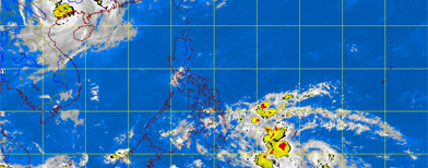
A tropical depression east of Southern Mindanao has entered the Philippine Area of Responsibility (PAR) and was named “Zoraida”.
A tropical depression east of Southern Mindanao has entered the Philippine Area of Responsibility (PAR) and was named “Zoraida”.
According to weather bureau PAGASA, Zoraida was last spotted 830 kilometers Southeast of Hinatuan, Surigao Del Sur. It is weaker than Yolanda with maximum sustained winds of 55 kilometers per hour near the center.
It is forecast to move northwest at 30 kilometers per hour and is threatening to hit northern Mindanao and the Visayas region. The storm is expected to be 160 kilometers east southeast of Hinatuan, Surigao del Sur on Tuesday morning, the vicinity of Cuyo or 130 kilometers west of Iloilo City on Wednesday and 650 kilometers west of San Jose, Occidental Mindoro on Thursday morning.
Public Storm Warning Signal no. 1 has been raised over Siquijor, Southern Cebu, Bohol, Negros Oriental, Southern Negros Occidental in Visayas and Dinagat province, Siargao Island, Agusan del Norte, Agusan del Sur, Surigao del Norte, Davao del Norte including Samal Island, Surigao del Sur, Bukidnon, Misamis Oriental, Camiguin island and Davao Oriental in Mindanao.
Sea travel is risky over the northern seaboard of Northern Luzon and the eastern seaboards of Northern and Central Luzon.
Just last week, Yolanda battered the Visayas region. At least 255 people were confirmed dead as of Monday morning.

Bagyo na naman?!
ReplyDelete