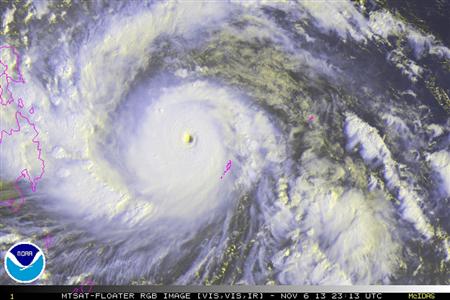
International weather monitoring groups have tagged “Yolanda” (international name Haiyan) a super typhoon, warning the Philippines against a trail of death and destruction.
“Haiyan became a super typhoon Wednesday morning,” commercial weather service Accuweather said, calling Yolanda the world’s “strongest tropical system” this year.
“Haiyan became a super typhoon Wednesday morning,” commercial weather service Accuweather said, calling Yolanda the world’s “strongest tropical system” this year.
The U.S. Joint Typhoon Warning Center also called Yolanda a super typhoon, but added that it may still strengthen as it crosses the country.
A bulletin by the U.S. National Environmental Satellite, Data and Information Service meanwhile said Yolanda “has developed to almost max intensity for a cyclone.”
“Based on satellite imagery, [Haiyan’s] the strongest storm I’ve seen since Bopha,” a Washington post report quoted WeatherBell meteorologist Ryan Maue as saying.
Bopha—named Pablo as it entered the Philippine area of responsibility—hit Mindanao in December 2012, killing hundreds in flashfloods and landslides.
“Widespread torrential rain and damaging winds will accompany Haiyan through the central Philippines, threatening to leave a trail of destruction and triggering life-threatening flash floods,” Accuweather said.
The Philippine Atmospheric, Geophysical and Astronomic Services Administration (Pagasa) expects Yolanda to make landfall in the Samar-Leyte area Friday.
It is also forecast to directly impact Visayas areas of Leyte, Cebu, Biliran, Iloilo, Capiz, Aklan, Romblon, Mindoro, Busuanga and Semirara Island.
Storm warning signals have been raised in several areas, with Pagasa warning residents against possible floods and landslides, as well as storm surges in coastal areas.
The weather bureau earlier said it may raise the rarely used storm warning signal number 4 in some areas in Yolanda’s path, especially the countries’ southern provinces.
Accuweather said “the worst of the storm will bypass the capital city of Manila, but damaging winds of 80 to 120 kph and rainfall of 100 to 200 mm are still expected.”
It however warned of the storm’s impact on Cebu and Bohol, which have recently been hit by a strong typhoon. The two areas are now under signal number 2.

0 comments:
Post a Comment